How to get there
Directions to Tapada do gramacho
We are not difficult to find, but you might need some help. We strongly advise you to print the directions below and have it at hand when you drive to us!
Unfortunately navigation systems are not completely reliable in the Algarve, but you schould be able to use Google maps or TomTom to get there. Don't hesitate to call us if you need got lost and need some help: +351 919667048.
Google Maps: just click here to get the exact location, or simply search for "Tapada do Gramacho"
TomTom: Search for "Tapada do Gramacho, Estombar"
GPS coordinates: 37.1752793, -8.4702207
Keep following description at hand! Download in high resulotion here: ![]()
Don't hesitate to call us if you need help: +351 919667048.
Directions coming from Lisboa
1. From the A2 take exit number 14 direction Silves. Follow the N-124 to Silves;
2. Keep on going straight ahead at the first roundabout in Silves;
3. Cross the bridge at your left hand side and turn right reaching the other side direction Portimão/Lagoa;
4. Then, just after the tunel turn right at the exit “Estação”;
5. At the roundabout follow direction Arrochela/Estombar.
Now please continue with the foto directions 5 to 7 mentioned here below
Directions coming from the A22: airport Faro or Lagos
1. From the airport, take the A22 motorway towards Lagos and Portimão (Coming from Lagos follow A22 towards Faro). From this A22 take the exit N124-1 direction Silves;
2. Once on the N124-1, before you have reached Silves, take the exit "Estaçao";
3. At the first roundabout, go right (the 1st exit) direction Lagoa;
4. At the second roundabout, go straight (1st exit) direction Arrochela/Estombar;
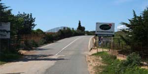
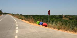
5. You are now on a poorly paved road. At the moment the road surface changes into a better quality and you see the lines on it, drive another 1.1 km before you see a STOP sign with 3 large stones below; (See next picture)
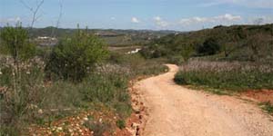
6. Go sharply right here and follow the dirt road;
7. After about 700m we will welcome you at Tapada do Gramacho!